Tag Archives: richter scale

The Great San Francisco Earthquake (18 April 1906)

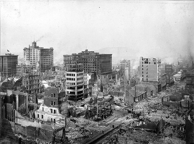
Northeast View of Post & Grant Avenues, San Francisco, 18 April 1906
Public Domain (National Archives and Records Administration, ARC Identifier: 524396)

At 5:12 a.m. on 18 April 1906, Northern California was awakened by an earthquake that is now considered one of the most significant of all time. The epicenter was near San Francisco and the shaking lasted between 45-60 seconds. It was so powerful that it was felt from southern Oregon to Los Angeles and as far east as central Nevada. The intensity showed the clear difference between bedrock and sediment (or land filled) geology. Those that got the strongest shaking were in sediment filled areas rather than bedrock. Which explains why in San Francisco the damage was the most severe in those areas. Specifically it is the area called SOMA (South of Market or the old term south of the slot)where the greatest damage resulted. That area used to be part of San Francisco Bay but was filled in for more housing, commercial, and industrial uses. Houses and buildings were damaged or collapsed.
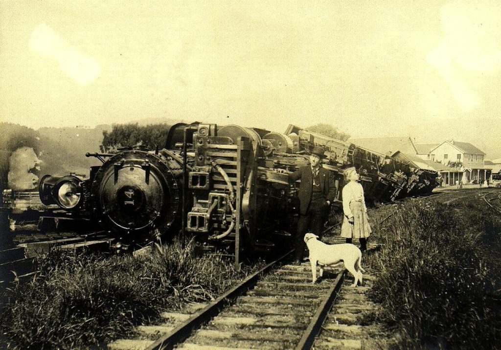
The train was standing on a siding. Beyond are the buildings of the Point Reyes Hotel, and at the extreme right the ruin of a stone store which was shaken down.Point Reyes Station, west Marin County, California. April 18, 1906
Image: G.K. Gilbert
Source: Photographs from the U.S. Geological Survey Photographic Library (CD-Rom)
Public Domain via Wikimedia Commons

Although San Francisco got a significant amount of damage, other areas were likewise damaged. Cities like Santa Rosa got hit hard(the entire downtown was destroyed) and many in the countryside suffered building or infrastructure damage as well. The magnitude of the quake was originally thought to be around 8.3 on the Richter scale. However others argue it was between 7.7 and 7.9 based on new interpretations of earthquake data. However you measure it, the earthquake was one of the most severe in the modern era. The earthquake not only destroyed buildings, injured scores and killing 3,000 (estimated) but caused the fires that made it much worse with water supply being severely limited by broken pipes. City leaders would claim later, to ensure people would come back to the city, that San Francisco was not destroyed by the earthquake but the fires. The truth was (and later researchers would learn this)how extensive the earthquake had been to San Francisco. The fires were a direct result of the earthquake and made a bad situation that much worse. The Army used dynamite to blow up areas to block fires. This usually is a good tactic to blow up ground to create firebreaks. This made it much worse since no one thought about the possibility of flying embers from blown up buildings causing more fires. Which is what happened and made it that much worse.

Today we look back at the old pictures but not really appreciate the total magnitude of the disaster. San Francisco rebuilt but continued its old ways for a long time. Buildings went up in the very areas worst hit by the earthquake with little attention to earthquake safety. But by the late 20th century that had changed as city leaders realized how damaging another 1906 type of quake would be to a modern city. New ordinances were passed and many of the taller buildings in San Francisco today in the Financial District were constructed to handle earthquakes.
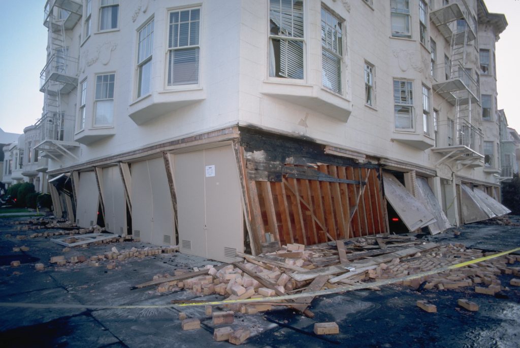
Photograph of a collapsed facade of a building near Beach and Divisadero Streets in San Francisco October 1989
Photo: J.K. Nakata, United States Geological Survey
Public Domain via Wikimedia Commons

I learned this from being in one such building during the Loma Prieta Earthquake (17 Oct 1989 at 5:07pm). That earthquake was centered near Santa Cruz and measured 6.9, much less powerful than 1906. But it caused a lot of damage and some loss of life as well. The building I was in (since it is on landfill) was built to sway with the earthquake rather than remain locked in place. It was a weird experience to feel the building rock as it did but it survived just fine while a building across the street and built long before that standard had its top cave in. That building had to be torn down.

Some things did stay the same as 1906. There was little official guidance, mass transit was down, lots of cars stuck in traffic, and plenty of people milling about trying to figure out how to get home. I was lucky as I took a SamTrans bus to Daly City from the old Transbay Terminal. It was long bus ride that took close to 3 hours but I was grateful that bus was running. Those living in the East Bay would have to wait a good long while for BART to run again. And those that watched the World Series that night saw an earthquake live at old Candlestick Park.

Additional Information

The Great 1906 San Francisco Earthquake (USGS)
San Francisco Earthquake, 1906(National Archives)
New S.F. archive includes stunning photos from 1906 quake(S.F. Chronicle,17 April 2015)
San Francisco earthquake and fire, April 18, 1906 (Library of Congress) 1906 film that shows the damage.
The 1906 San Francisco Earthquake and Fire (Bancroft Library Online Exhibit)
April 18, 1906: The Great San Francisco Earthquake

Northeast View of Post & Grant Avenues, San Francisco, 18 April 1906
Public Domain (National Archives and Records Administration, ARC Identifier: 524396)

At 5:12 a.m. on 18 April 1906, Northern California was awakened by an earthquake that is now considered one of the most significant of all time. The epicenter was near San Francisco and the shaking lasted between 45-60 seconds. It was so powerful that it was felt from southern Oregon to Los Angeles and as far east as central Nevada. The intensity showed the clear difference between bedrock and sediment (or land filled) geology. Those that got the strongest shaking were in sediment filled areas rather than bedrock. Which explains why in San Francisco the damage was the most severe in those areas. Specifically it is the area called SOMA (South of Market or the old term south of the slot)where the greatest damage resulted. That area used to be part of San Francisco Bay but was filled in for more housing, commercial, and industrial uses. Houses and buildings were damaged or collapsed.

The train was standing on a siding. Beyond are the buildings of the Point Reyes Hotel, and at the extreme right the ruin of a stone store which was shaken down.Point Reyes Station, west Marin County, California. April 18, 1906
Image: G.K. Gilbert
Source: Photographs from the U.S. Geological Survey Photographic Library (CD-Rom)
Public Domain via Wikimedia Commons

Although San Francisco got a significant amount of damage, other areas were likewise damaged. Cities like Santa Rosa got hit hard(the entire downtown was destroyed) and many in the countryside suffered building or infrastructure damage as well. The magnitude of the quake was originally thought to be around 8.3 on the Richter scale. However others argue it was between 7.7 and 7.9 based on new interpretations of earthquake data. However you measure it, the earthquake was one of the most severe in the modern era. The earthquake not only destroyed buildings, injured scores and killing 3,000 (estimated) but caused the fires that made it much worse with water supply being severely limited by broken pipes. City leaders would claim later, to ensure people would come back to the city, that San Francisco was not destroyed by the earthquake but the fires. The truth was (and later researchers would learn this)how extensive the earthquake had been to San Francisco. The fires were a direct result of the earthquake and made a bad situation that much worse. The Army used dynamite to blow up areas to block fires. This usually is a good tactic to blow up ground to create firebreaks. This made it much worse since no one thought about the possibility of flying embers from blown up buildings causing more fires. Which is what happened and made it that much worse.

Today we look back at the old pictures but not really appreciate the total magnitude of the disaster. San Francisco rebuilt but continued its old ways for a long time. Buildings went up in the very areas worst hit by the earthquake with little attention to earthquake safety. But by the late 20th century that had changed as city leaders realized how damaging another 1906 type of quake would be to a modern city. New ordinances were passed and many of the taller buildings in San Francisco today in the Financial District were constructed to handle earthquakes.

Photograph of a collapsed facade of a building near Beach and Divisadero Streets in San Francisco October 1989
Photo: J.K. Nakata, United States Geological Survey
Public Domain via Wikimedia Commons

I learned this from being in one such building during the Loma Prieta Earthquake (17 Oct 1989 at 5:07pm). That earthquake was centered near Santa Cruz and measured 6.9, much less powerful than 1906. But it caused a lot of damage and some loss of life as well. The building I was in (since it is on landfill) was built to sway with the earthquake rather than remain locked in place. It was a weird experience to feel the building rock as it did but it survived just fine while a building across the street and built long before that standard had its top cave in. That building had to be torn down.

Some things did stay the same as 1906. There was little official guidance, mass transit was down, lots of cars stuck in traffic, and plenty of people milling about trying to figure out how to get home. I was lucky as I took a SamTrans bus to Daly City from the old Transbay Terminal. It was long bus ride that took close to 3 hours but I was grateful that bus was running. Those living in the East Bay would have to wait a good long while for BART to run again. And those that watched the World Series that night saw an earthquake live at old Candlestick Park.

Additional Information

The Great 1906 San Francisco Earthquake (USGS)
San Francisco Earthquake, 1906(National Archives)
New S.F. archive includes stunning photos from 1906 quake(S.F. Chronicle,17 April 2015)
San Francisco earthquake and fire, April 18, 1906 (Library of Congress) 1906 film that shows the damage.
The 1906 San Francisco Earthquake and Fire (Bancroft Library Online Exhibit)

April 18, 1906: The Great San Francisco Earthquake

Northeast View of Post & Grant Avenues, San Francisco, 18 April 1906 Public Domain (National Archives and Records Administration, ARC Identifier: 524396)
Northeast View of Post & Grant Avenues, San Francisco, 18 April 1906
Public Domain (National Archives and Records Administration, ARC Identifier: 524396)

At 5:12 a.m. on 18 April 1906, Northern California was awakened by an earthquake that is now considered one of the most significant of all time. The epicenter was near San Francisco and the shaking lasted between 45-60 seconds. It was so powerful that it was felt from southern Oregon to Los Angeles and as far east as central Nevada. The intensity showed the clear difference between bedrock and sediment (or land filled) geology. Those that got the strongest shaking were in sediment filled areas rather than bedrock. Which explains why in San Francisco the damage was the most severe in those areas. Specifically it is the area called SOMA (South of Market or the old term south of the slot)where the greatest damage resulted. That area used to be part of San Francisco Bay but was filled in for more housing, commercial, and industrial uses. Houses and buildings were damaged or collapsed.

This train was on a siding when the earthquake hit on 18 April 1906 and thrown down. In the far right you can see the ruin of a stone store destroyed by the earthquake. Public Domain (USGS)
This train in Point Reyes was on a siding when the earthquake hit on 18 April 1906 and thrown down. In the far right you can see the ruin of a stone store destroyed by the earthquake.
Public Domain (USGS)

Although San Francisco got a significant amount of damage, other areas were likewise damaged. Cities like Santa Rosa got hit hard(the entire downtown was destroyed) and many in the countryside suffered building or infrastructure damage as well. The magnitude of the quake was originally thought to be around 8.3 on the Richter scale. However others argue it was between 7.7 and 7.9 based on new interpretations of earthquake data. However you measure it, the earthquake was one of the most severe in the modern era. The earthquake not only destroyed buildings, injured scores and killing 3,000 (estimated) but caused the fires that made it much worse with water supply being severely limited by broken pipes. City leaders would claim later, to ensure people would come back to the city, that San Francisco was not destroyed by the earthquake but the fires. The truth was (and later researchers would learn this)how extensive the earthquake had been to San Francisco. The fires were a direct result of the earthquake and made a bad situation that much worse. The Army used dynamite to blow up areas to block fires. This usually is a good tactic to blow up ground to create firebreaks. This made it much worse since no one thought about the possibility of flying embers from blown up buildings causing more fires. Which is what happened and made it that much worse.

Today we look back at the old pictures but not really appreciate the total magnitude of the disaster. San Francisco rebuilt but continued its old ways for a long time. Buildings went up in the very areas worst hit by the earthquake with little attention to earthquake safety. But by the late 20th century that had changed as city leaders realized how damaging another 1906 type of quake would be to a modern city. New ordinances were passed and many of the taller buildings in San Francisco today in the Financial District were constructed to handle earthquakes.

photograph of a collapsed facade of a building near Beach and Divisadero Streets in San Francisco
October 1989
U.S. Geological Survey
Public Domain

I learned this from being in one such building during the Loma Prieta Earthquake (17 Oct 1989 at 5:07pm). That earthquake was centered near Santa Cruz and measured 6.9, much less powerful than 1906. But it caused a lot of damage and some loss of life as well. The building I was in (since it is on landfill) was built to sway with the earthquake rather than remain locked in place. It was a weird experience to feel the building rock as it did but it survived just fine while a building across the street and built long before that standard had its top cave in. That building had to be torn down.

Some things did stay the same as 1906. There was little official guidance, mass transit was down, lots of cars stuck in traffic, and plenty of people milling about trying to figure out how to get home. I was lucky as I took a SamTrans bus to Daly City from the old Transbay Terminal. It was long bus ride that took close to 3 hours but I was grateful that bus was running. Those living in the East Bay would have to wait a good long while for BART to run again. And those that watched the World Series that night saw an earthquake live at old Candlestick Park.

Additional Information

The Great 1906 San Francisco Earthquake (USGS)
San Francisco Earthquake, 1906(National Archives)
New S.F. archive includes stunning photos from 1906 quake(S.F. Chronicle,17 April 2015)
San Francisco earthquake and fire, April 18, 1906 (Library of Congress) 1906 film that shows the damage.
The 1906 San Francisco Earthquake and Fire (Bancroft Library Online Exhibit)

April 18, 1906-the day the earth shook and fire sprang forth in san francisco

Northeast View of Post & Grant Avenues, San Francisco, 18 April 1906 Public Domain (National Archives and Records Administration, ARC Identifier: 524396)
Northeast View of Post & Grant Avenues, San Francisco, 18 April 1906
Public Domain (National Archives and Records Administration, ARC Identifier: 524396)

At 5:12 a.m. on 18 April 1906, Northern California was awakened by an earthquake that is now considered one of the most significant of all time. The epicenter was near San Francisco and the shaking lasted between 45-60 seconds. It was so powerful that it was felt from southern Oregon to Los Angeles and as far east as central Nevada. The intensity showed the clear difference between bedrock and sediment (or land filled) geology. Those that got the strongest shaking were in sediment filled areas rather than bedrock. Which explains why in San Francisco the damage was the most severe in those areas. Specifically it is the area called SOMA (South of Market or the old term south of the slot)where the greatest damage resulted. That area used to be part of San Francisco Bay but was filled in for more housing, commercial, and industrial uses. Houses and buildings were damaged or collapsed.

This train was on a siding when the earthquake hit on 18 April 1906 and thrown down. In the far right you can see the ruin of a stone store destroyed by the earthquake. Public Domain (USGS)
This train in Point Reyes was on a siding when the earthquake hit on 18 April 1906 and thrown down. In the far right you can see the ruin of a stone store destroyed by the earthquake.
Public Domain (USGS)

Although San Francisco got a significant amount of damage, other areas were likewise damaged. Cities like Santa Rosa got hit hard(the entire downtown was destroyed) and many in the countryside suffered building or infrastructure damage as well. The magnitude of the quake was originally thought to be around 8.3 on the Richter scale. However others argue it was between 7.7 and 7.9 based on new interpretations of earthquake data. However you measure it, the earthquake was one of the most severe in the modern era. The earthquake not only destroyed buildings, injured scores and killing 3,000 (estimated) but caused the fires that made it much worse with water supply being severely limited by broken pipes. City leaders would claim later, to ensure people would come back to the city, that San Francisco was not destroyed by the earthquake but the fires. The truth was (and later researchers would learn this)how extensive the earthquake had been to San Francisco. The fires were a direct result of the earthquake and made a bad situation that much worse. The Army used dynamite to blow up areas to block fires. This usually is a good tactic to blow up ground to create firebreaks. This made it much worse since no one thought about the possibility of flying embers from blown up buildings causing more fires. Which is what happened and made it that much worse.

Today we look back at the old pictures but not really appreciate the total magnitude of the disaster. San Francisco rebuilt but continued its old ways for a long time. Buildings went up in the very areas worst hit by the earthquake with little attention to earthquake safety. But by the late 20th century that had changed as city leaders realized how damaging another 1906 type of quake would be to a modern city. New ordinances were passed and many of the taller buildings in San Francisco today in the Financial District were constructed to handle earthquakes.

photograph of a collapsed facade of a building near Beach and Divisadero Streets in San Francisco
October 1989
U.S. Geological Survey
Public Domain

I learned this from being in one such building during the Loma Prieta Earthquake (17 Oct 1989 at 5:07pm). That earthquake was centered near Santa Cruz and measured 6.9, much less powerful than 1906. But it caused a lot of damage and some loss of life as well. The building I was in (since it is on landfill) was built to sway with the earthquake rather than remain locked in place. It was a weird experience to feel the building rock as it did but it survived just fine while a building across the street and built long before that standard had its top cave in. That building had to be torn down.

Some things did stay the same as 1906. There was little official guidance, mass transit was down, lots of cars stuck in traffic, and plenty of people milling about trying to figure out how to get home. I was lucky as I took a SamTrans bus to Daly City from the old Transbay Terminal. It was long bus ride that took close to 3 hours but I was grateful that bus was running. Those living in the East Bay would have to wait a good long while for BART to run again. And those that watched the World Series that night saw an earthquake live at old Candlestick Park.

Additional Information

The Great 1906 San Francisco Earthquake (USGS)
San Francisco Earthquake, 1906(National Archives)
New S.F. archive includes stunning photos from 1906 quake(S.F. Chronicle,17 April 2015)
San Francisco earthquake and fire, April 18, 1906 (Library of Congress) 1906 film that shows the damage.
The 1906 San Francisco Earthquake and Fire (Bancroft Library Online Exhibit)

April 18, 1906: The Earth Shook and Fire Sprang Forth

Northeast View of Post & Grant Avenues, San Francisco, 18 April 1906 Public Domain (National Archives and Records Administration, ARC Identifier: 524396)
Northeast View of Post & Grant Avenues, San Francisco, 18 April 1906
Public Domain (National Archives and Records Administration, ARC Identifier: 524396)

At 5:12 a.m. on 18 April 1906, Northern California was awakened by an earthquake that is now considered one of the most significant of all time. The epicenter was near San Francisco and the shaking lasted between 45-60 seconds. It was so powerful that it was felt from southern Oregon to Los Angeles and as far east as central Nevada. The intensity showed the clear difference between bedrock and sediment (or land filled) geology. Those that got the strongest shaking were in sediment filled areas rather than bedrock. Which explains why in San Francisco the damage was the most severe in those areas. Specifically it is the area called SOMA (South of MarketĀ  or the old term south of the slot)where the greatest damage resulted. That area used to be part of San Francisco Bay but was filled in for more housing, commercial, and industrial uses. Houses and buildings were damaged or collapsed.

This train was on a siding when the earthquake hit on 18 April 1906 and thrown down. In the far right you can see the ruin of a stone store destroyed by the earthquake. Public Domain (USGS)
This train in Point Reyes was on a siding when the earthquake hit on 18 April 1906 and thrown down. In the far right you can see the ruin of a stone store destroyed by the earthquake.
Public Domain (USGS)

Although San Francisco got a significant amount of damage, other areas were likewise damaged. Cities like Santa Rosa got hit hard(the entire downtown was destroyed) and many in the countryside suffered building or infrastructure damage as well. The magnitude of the quake was originally thought to be around 8.3 on the Richter scale. However others argue it was between 7.7 and 7.9 based on new interpretations of earthquake data. However you measure it, the earthquake was one of the most severe in the modern era. The earthquake not only destroyed buildings, injured scores and killing 3,000 (estimated) but caused the fires that made it much worse with water supply being severely limited by broken pipes. City leaders would claim later, to ensure people would come back to the city, that San Francisco was not destroyed by the earthquake but the fires. The truth was (and later researchers would learn this)how extensive the earthquake had been to San Francisco. The fires were a direct result of the earthquake and made a bad situation that much worse. The Army used dynamite to blow up areas to block fires. This usually is a good tactic to blow up ground to create firebreaks. This made it much worse since no one thought about the possibility of flying embers from blown up buildings causing more fires. Which is what happened and made it that much worse.

Today we look back at the old pictures but not really appreciate the total magnitude of the disaster. San Francisco rebuilt but continued its old ways for a long time. Buildings went up in the very areas worst hit by the earthquake with little attention to earthquake safety. But by the late 20th century that had changed as city leaders realized how damaging another 1906 type of quake would be to a modern city. New ordinances were passed and many of the taller buildings in San Francisco today in the Financial District were constructed to handle earthquakes. I learned this from being in one such building during the Loma Prieta Earthquake (17 Oct 1989 at 5:07pm). That earthquake was centered near Santa Cruz and measured 6.9, much less powerful than 1906. But it caused a lot of damage and some loss of life as well. The building I was in (since it is on landfill) was built to sway with the earthquake rather than remain locked in place. It was a weird experience to feel the building rock as it did but it survived just fine while a building across the street and built long before that standard had its top cave in. That building had to be torn down.

Some things did stay the same as 1906. There was little official guidance, mass transit was down, lots of cars stuck in traffic, and plenty of people milling about trying to figure out how to get home. I was lucky as I took a SamTrans bus to Daly City from the old Transbay Terminal. It was long bus ride that took close to 3 hours but I was grateful that bus was running. Those living in the East Bay would have to wait a good long while for BART to run again. And those that watched the World Series that night saw an earthquake live at old Candlestick Park.

Additional Information

The Great 1906 San Francisco Earthquake (USGS)
San Francisco Earthquake, 1906(National Archives)
New S.F. archive includes stunning photos from 1906 quake(S.F. Chronicle,17 April 2015)
San Francisco earthquake and fire, April 18, 1906 (Library of Congress) 1906 film that shows the damage.
The 1906 San Francisco Earthquake and Fire (Bancroft Library Online Exhibit)

April 18, 1906: The Earth Shook and Fire Sprang Forth

Northeast View of Post & Grant Avenues, San Francisco, 18 April 1906 Public Domain (National Archives and Records Administration, ARC Identifier: 524396)
Northeast View of Post & Grant Avenues, San Francisco, 18 April 1906
Public Domain (National Archives and Records Administration, ARC Identifier: 524396)

At 5:12 a.m. Northern California was awakened by an earthquake that is now considered one of the most significant of all time. The epicenter was near San Francisco and the shaking lasted between 45-60 seconds. It was so powerful that it was felt from southern Oregon to Los Angeles and as far east as central Nevada. The intensity showed the clear difference between bedrock and sediment (or land filled) geology. Those that got the strongest shaking were in sediment filled areas rather than bedrock. Which explains why in San Francisco the damage was the most severe in those areas. Specifically it is the area called SOMA (South of MarketĀ  or the old term south of the slot)where the greatest damage resulted. That area used to be part of San Francisco Bay but was filled in for more housing, commercial, and industrial uses. Houses and buildings were damaged or collapsed.

Although San Francisco got a significant amount of damage, other areas were likewise damaged. Cities like Santa Rosa got hit hard(the entire downtown was destroyed) and many in the countryside suffered building or infrastructure damage as well. The magnitude of the quake was originally thought to be around 8.3 on the Richter scale. However others argue it was between 7.7 and 7.9 based on new interpretations of earthquake data. However you measure it, the earthquake was one of the most severe in the modern era. The earthquake not only destroyed buildings, injured scores and killing 3,000 (estimated) but caused the fires that made it much worse with water supply being severely limited by broken pipes. City leaders would claim later, to ensure people would come back to the city, that San Francisco was not destroyed by the earthquake but the fires. The truth was (and later researchers would learn this)how extensive the earthquake had been to San Francisco. The fires were a direct result of the earthquake and made a bad situation that much worse. The Army used dynamite to blow up areas to block fires. This usually is a good tactic to blow up ground to create firebreaks. This made it much worse since no one thought about the possibility of flying embers from blown up buildings causing more fires. Which is what happened and made it that much worse.

Today we look back at the old pictures but not really appreciate the total magnitude of the disaster. San Francisco rebuilt but continued its old ways for a long time. Buildings went up in the very areas worst hit by the earthquake with little attention to earthquake safety. But by the late 20th century that had changed as city leaders realized how damaging another 1906 type of quake would be to a modern city. New ordinances were passed and many of the taller buildings in San Francisco today in the Financial District were constructed to handle earthquakes. I learned this from being in one such building during the Loma Prieta Earthquake (17 Oct 1989 at 5:07pm). That earthquake was centered near Santa Cruz and measured 6.9, much less powerful than 1906. But it caused a lot of damage and some loss of life as well. The building I was in (since it is on landfill) was built to sway with the earthquake rather than remain locked in place. It was a weird experience to feel the building rock as it did but it survived just fine while a building across the street and built long before that standard had its top cave in. That building had to be torn down.

Some things did stay the same as 1906. There was little official guidance, mass transit was down, lots of cars stuck in traffic, and plenty of people milling about trying to figure out how to get home. I was lucky as I took a SamTrans bus to Daly City from the old Transbay Terminal. It was long bus ride that took close to 3 hours but I was grateful that bus was running. Those living in the East Bay would have to wait a good long while for BART to run again. And those that watched the World Series that night saw an earthquake live at old Candlestick Park.

Additional Information

The Great 1906 San Francisco Earthquake (USGS)
San Francisco Earthquake, 1906(National Archives)
New S.F. archive includes stunning photos from 1906 quake(S.F. Chronicle,17 April 2015)
San Francisco earthquake and fire, April 18, 1906 (Library of Congress) 1906 film that shows the damage.
The 1906 San Francisco Earthquake and Fire (Bancroft Library Online Exhibit)