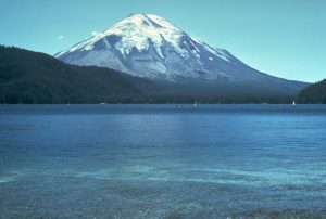
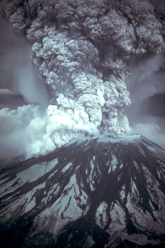
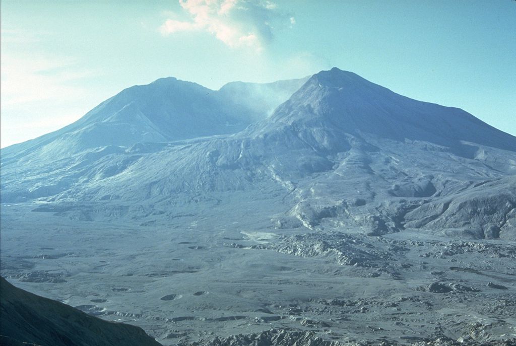
At 8:32 am on Sunday, 18 May 1980, Mount St. Helens erupted in one of America’s most notable eruptions killing 57 people and causing widespread destruction that forever changed that area.

Photo taken by Jim Nieland, US Forest Service.
Public Domain via Wikimedia Commons
Mount St. Helens is in the Cascade Range of Washington state and stood 9,680 feet before the 1980 eruption. Located 98 miles south of Seattle and 52 miles northeast of Portland, Oregon, it is considered the most active volcano in the Cascade Range. It last erupted in the 19th century. The area it was in a popular area for sportsman, campers, hikers and generally anyone who wanted to enjoy the lovely area. Nearby Spirit Lake had numerous lodges where people could stay and fish on the lake. The most notable was Mt. St. Helens Lodge owned by Harry R. Truman who famously refused to comply with the evacuation order and ultimately died in the eruption.
The first sign of activity began on 16 March 1980 with a series of small earthquakes. Finally on 27 March, the volcano erupted for the first time in over 100 years with steam explosions that blasted a 200–250-foot crater in the summit. A week later the crater had expanded to 1,300 feet and two giant crack systems appeared crossing the entire summit area. Eruptions stopped on 22 April but then picked up again on 7 May and all the way to 17 May. Earthquakes now grew to over 10,000 and the north flank had a noticeable bulge growing outward at a consistent rate of 6.5 feet per day. This told the geologists that molten rock (magma) had risen high in the volcano. This was an alarming state and why evacuations were ordered, and people told to stay away.

Photo: Austin Post, USGS
Public Domain
An earthquake at 8:32 am on 18 May 1980 occurred and the northern bulge and summit became the largest debris avalanche on Earth ever recorded. An eruption plume rose from the summit crater up 650 feet in the air. The debris avalanche swept north at first then turned westward at speeds of 14 mph down the North Fork Toutle River forming a deposit and a volume of 3.3. billion cubic yards. The lateral blast from the volcano, the first ever recorded, would overtake the avalanche speeding 300 miles per hour of hot gas that would flatten the dense forest in the immediate area and leaving a 230-mile devastated area covered in hot debris. The eruption cloud would reach 80,000 feet and would continue erupting for 9 hours. Prevailing winds carried 520 million tons of ash eastward across the United States. Cities like Spokane and Yakima would suffer complete darkness as the ash cloud passed over them dropping tons of ash on homes, streets and just about everywhere. The ash fell in Montana and the Great Plains as well.
Aftermath
The eruption was the deadliest in terms of lives and economically destructive to date in the continental United States. In addition to 57 lives killed directly from the eruption, 200 houses, 47 bridges, 15 miles of railway, and 185 miles of highway were destroyed. Due to the lateral explosion, the height of the mountain was reduced by 1,300 feet with a crater of 2 miles wide and 2,100 feet deep with the north end open in a huge breach. Timber from the logging camps was damaged or destroyed, though about 25% of it was eventually salvaged. The thick ash fell downwind on areas where agricultural crops were grown. Wheat, apples, potatoes and alfalfa were destroyed by the ash. Needless to say, all the deer and elk in the area were killed in the eruption along with millions of salmon when the hatcheries were destroyed. According to the U.S. Geological Survey report, Mount St. Helens released 24 megatons TNT (7 came from the blast itself) which is equivalent to 1,600 times the size of the atomic bomb dropped on Hiroshima.

Photo: Harry Glicken, USGS
Public Domain
Cleaning up the ash literally became a Herculean task. The ash fall itself closed highways, made driving difficult due to low visibility, and air traffic had to be contained. With all the ash, it became a major task to clean it all up after the eruption had subsided. Ash caused significant damage to filtration systems in cars, contaminated oil and water, and the fine particles damaged glass in vehicles, buildings, and anything else it was blown into. Removing all the ash was not easy. For homeowners and cities, the ash could not be simply washed away as it became sludge and even more of a problem. It had to be either shoveled or mechanically collected and moved away from where it fell. Due to closed roads and other civil works closed by the ash, it had to be moved quickly to wherever could be dumped such as quarries, landfills, or anyplace that could take the ash. For both homeowners and cities, it was a nightmare to deal with but it was eventually all cleaned up though sometimes, while driving out many remote areas of Washington state, you might places where the ash is still lingering.
For Washington state, it took a massive hit on tourism for a while, especially in the area near Mount St. Helens as various meetings, conventions, or other events were cancelled or moved elsewhere. The once beautiful area that people loved to visit though was forever changed. While it no longer looks like the surface of the moon, life has returned as nature has started to remake the area. The geologist who took the incredible photographs of the eruption and first to report of it– David A. Johnston–died at the observation post. The USGS trailer was found in 1993 but his body was never recovered. Two volcanic observatories were named for him: Johnston Ridge Observatory near Mount St. Helens and the USGS office in Vancouver was renamed David A. Johnston Cascades Volcano Observatory. A memorial fund at University of Washington, where he did his graduate and doctoral studies, was created. Two trees were planted in his honor in Tel Aviv, Israel and in his hometown the community center was renamed Johnston Center.
Sources
—. “Mount St. Helens Erupts.” HISTORY, 17 May 2022, www.history.com/this-day-in-history/mount-st-helens-erupts-2.
—. “Mount Saint Helens | Location, Eruption, Map, and Facts.” Encyclopedia Britannica, 10 May 2024, www.britannica.com/place/Mount-Saint-Helens.
1980 Cataclysmic Eruption | U.S. Geological Survey. www.usgs.gov/volcanoes/mount-st.-helens/science/1980-cataclysmic-eruption.
Rhp. “The Eruption of Mount St. Helens in Pictures, 1980.” Rare Historical Photos, 4 Nov. 2021, rarehistoricalphotos.com/eruption-mount-st-helens-1980.
