Tag Archives: San Francisco

April 18, 1906: The Great San Francisco Earthquake

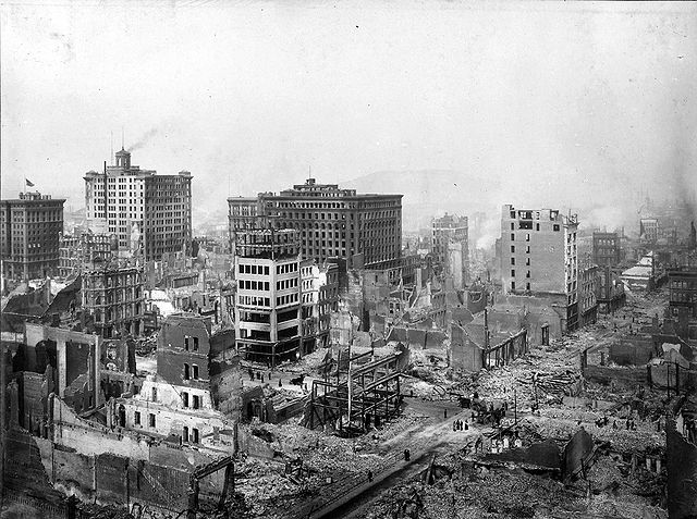
Northeast View of Post & Grant Avenues, San Francisco, 18 April 1906 Public Domain (National Archives and Records Administration, ARC Identifier: 524396)
Northeast View of Post & Grant Avenues, San Francisco, 18 April 1906
Public Domain (National Archives and Records Administration, ARC Identifier: 524396)

At 5:12 a.m. on 18 April 1906, Northern California was awakened by an earthquake that is now considered one of the most significant of all time. The epicenter was near San Francisco and the shaking lasted between 45-60 seconds. It was so powerful that it was felt from southern Oregon to Los Angeles and as far east as central Nevada. The intensity showed the clear difference between bedrock and sediment (or land filled) geology. Those that got the strongest shaking were in sediment filled areas rather than bedrock. Which explains why in San Francisco the damage was the most severe in those areas. Specifically it is the area called SOMA (South of Market or the old term south of the slot)where the greatest damage resulted. That area used to be part of San Francisco Bay but was filled in for more housing, commercial, and industrial uses. Houses and buildings were damaged or collapsed.
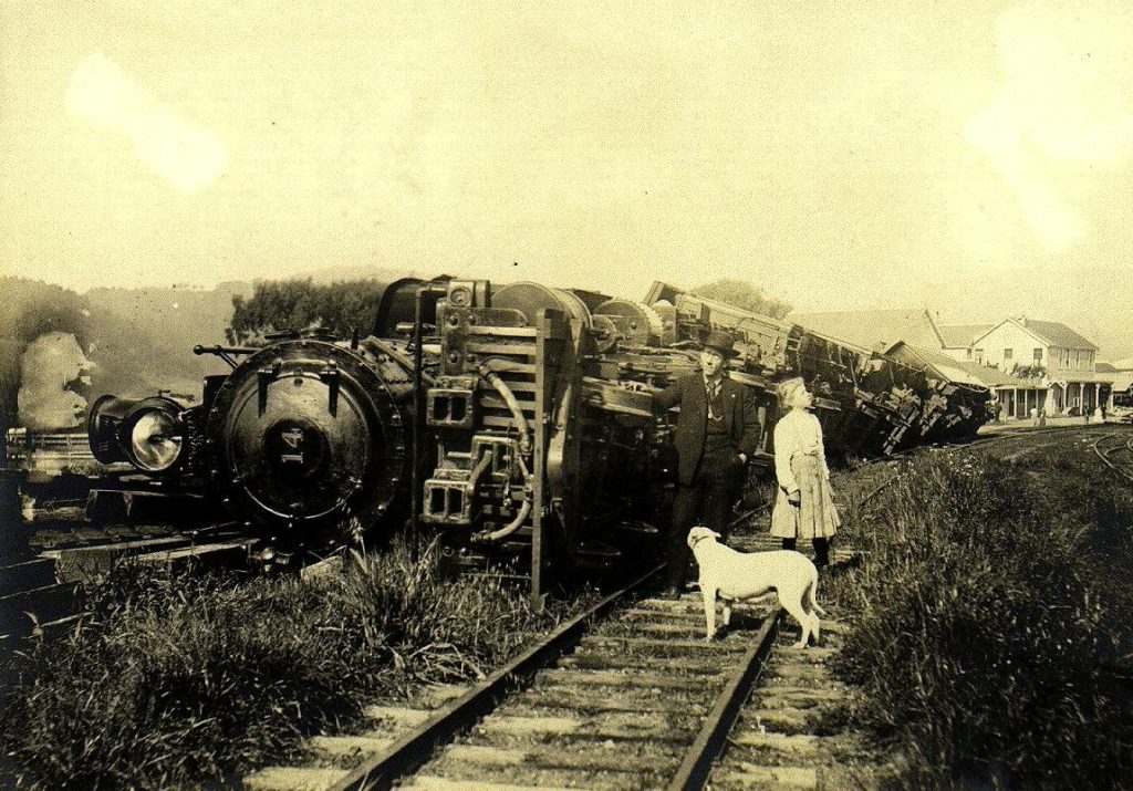
This train was on a siding when the earthquake hit on 18 April 1906 and thrown down. In the far right you can see the ruin of a stone store destroyed by the earthquake. Public Domain (USGS)
This train in Point Reyes was on a siding when the earthquake hit on 18 April 1906 and thrown down. In the far right you can see the ruin of a stone store destroyed by the earthquake.
Public Domain (USGS)

Although San Francisco got a significant amount of damage, other areas were likewise damaged. Cities like Santa Rosa got hit hard(the entire downtown was destroyed) and many in the countryside suffered building or infrastructure damage as well. The magnitude of the quake was originally thought to be around 8.3 on the Richter scale. However others argue it was between 7.7 and 7.9 based on new interpretations of earthquake data. However you measure it, the earthquake was one of the most severe in the modern era. The earthquake not only destroyed buildings, injured scores and killing 3,000 (estimated) but caused the fires that made it much worse with water supply being severely limited by broken pipes. City leaders would claim later, to ensure people would come back to the city, that San Francisco was not destroyed by the earthquake but the fires. The truth was (and later researchers would learn this)how extensive the earthquake had been to San Francisco. The fires were a direct result of the earthquake and made a bad situation that much worse. The Army used dynamite to blow up areas to block fires. This usually is a good tactic to blow up ground to create firebreaks. This made it much worse since no one thought about the possibility of flying embers from blown up buildings causing more fires. Which is what happened and made it that much worse.

Today we look back at the old pictures but not really appreciate the total magnitude of the disaster. San Francisco rebuilt but continued its old ways for a long time. Buildings went up in the very areas worst hit by the earthquake with little attention to earthquake safety. But by the late 20th century that had changed as city leaders realized how damaging another 1906 type of quake would be to a modern city. New ordinances were passed and many of the taller buildings in San Francisco today in the Financial District were constructed to handle earthquakes.
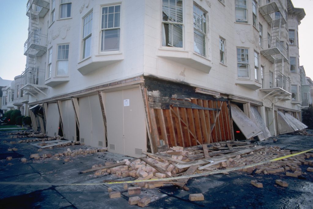
photograph of a collapsed facade of a building near Beach and Divisadero Streets in San Francisco
October 1989
U.S. Geological Survey
Public Domain

I learned this from being in one such building during the Loma Prieta Earthquake (17 Oct 1989 at 5:07pm). That earthquake was centered near Santa Cruz and measured 6.9, much less powerful than 1906. But it caused a lot of damage and some loss of life as well. The building I was in (since it is on landfill) was built to sway with the earthquake rather than remain locked in place. It was a weird experience to feel the building rock as it did but it survived just fine while a building across the street and built long before that standard had its top cave in. That building had to be torn down.

Some things did stay the same as 1906. There was little official guidance, mass transit was down, lots of cars stuck in traffic, and plenty of people milling about trying to figure out how to get home. I was lucky as I took a SamTrans bus to Daly City from the old Transbay Terminal. It was long bus ride that took close to 3 hours but I was grateful that bus was running. Those living in the East Bay would have to wait a good long while for BART to run again. And those that watched the World Series that night saw an earthquake live at old Candlestick Park.

Additional Information

The Great 1906 San Francisco Earthquake (USGS)
San Francisco Earthquake, 1906(National Archives)
New S.F. archive includes stunning photos from 1906 quake(S.F. Chronicle,17 April 2015)
San Francisco earthquake and fire, April 18, 1906 (Library of Congress) 1906 film that shows the damage.
The 1906 San Francisco Earthquake and Fire (Bancroft Library Online Exhibit)
April 18, 1906-the day the earth shook and fire sprang forth in san francisco

Northeast View of Post & Grant Avenues, San Francisco, 18 April 1906 Public Domain (National Archives and Records Administration, ARC Identifier: 524396)
Northeast View of Post & Grant Avenues, San Francisco, 18 April 1906
Public Domain (National Archives and Records Administration, ARC Identifier: 524396)

At 5:12 a.m. on 18 April 1906, Northern California was awakened by an earthquake that is now considered one of the most significant of all time. The epicenter was near San Francisco and the shaking lasted between 45-60 seconds. It was so powerful that it was felt from southern Oregon to Los Angeles and as far east as central Nevada. The intensity showed the clear difference between bedrock and sediment (or land filled) geology. Those that got the strongest shaking were in sediment filled areas rather than bedrock. Which explains why in San Francisco the damage was the most severe in those areas. Specifically it is the area called SOMA (South of Market or the old term south of the slot)where the greatest damage resulted. That area used to be part of San Francisco Bay but was filled in for more housing, commercial, and industrial uses. Houses and buildings were damaged or collapsed.

This train was on a siding when the earthquake hit on 18 April 1906 and thrown down. In the far right you can see the ruin of a stone store destroyed by the earthquake. Public Domain (USGS)
This train in Point Reyes was on a siding when the earthquake hit on 18 April 1906 and thrown down. In the far right you can see the ruin of a stone store destroyed by the earthquake.
Public Domain (USGS)

Although San Francisco got a significant amount of damage, other areas were likewise damaged. Cities like Santa Rosa got hit hard(the entire downtown was destroyed) and many in the countryside suffered building or infrastructure damage as well. The magnitude of the quake was originally thought to be around 8.3 on the Richter scale. However others argue it was between 7.7 and 7.9 based on new interpretations of earthquake data. However you measure it, the earthquake was one of the most severe in the modern era. The earthquake not only destroyed buildings, injured scores and killing 3,000 (estimated) but caused the fires that made it much worse with water supply being severely limited by broken pipes. City leaders would claim later, to ensure people would come back to the city, that San Francisco was not destroyed by the earthquake but the fires. The truth was (and later researchers would learn this)how extensive the earthquake had been to San Francisco. The fires were a direct result of the earthquake and made a bad situation that much worse. The Army used dynamite to blow up areas to block fires. This usually is a good tactic to blow up ground to create firebreaks. This made it much worse since no one thought about the possibility of flying embers from blown up buildings causing more fires. Which is what happened and made it that much worse.

Today we look back at the old pictures but not really appreciate the total magnitude of the disaster. San Francisco rebuilt but continued its old ways for a long time. Buildings went up in the very areas worst hit by the earthquake with little attention to earthquake safety. But by the late 20th century that had changed as city leaders realized how damaging another 1906 type of quake would be to a modern city. New ordinances were passed and many of the taller buildings in San Francisco today in the Financial District were constructed to handle earthquakes.

photograph of a collapsed facade of a building near Beach and Divisadero Streets in San Francisco
October 1989
U.S. Geological Survey
Public Domain

I learned this from being in one such building during the Loma Prieta Earthquake (17 Oct 1989 at 5:07pm). That earthquake was centered near Santa Cruz and measured 6.9, much less powerful than 1906. But it caused a lot of damage and some loss of life as well. The building I was in (since it is on landfill) was built to sway with the earthquake rather than remain locked in place. It was a weird experience to feel the building rock as it did but it survived just fine while a building across the street and built long before that standard had its top cave in. That building had to be torn down.

Some things did stay the same as 1906. There was little official guidance, mass transit was down, lots of cars stuck in traffic, and plenty of people milling about trying to figure out how to get home. I was lucky as I took a SamTrans bus to Daly City from the old Transbay Terminal. It was long bus ride that took close to 3 hours but I was grateful that bus was running. Those living in the East Bay would have to wait a good long while for BART to run again. And those that watched the World Series that night saw an earthquake live at old Candlestick Park.

Additional Information

The Great 1906 San Francisco Earthquake (USGS)
San Francisco Earthquake, 1906(National Archives)
New S.F. archive includes stunning photos from 1906 quake(S.F. Chronicle,17 April 2015)
San Francisco earthquake and fire, April 18, 1906 (Library of Congress) 1906 film that shows the damage.
The 1906 San Francisco Earthquake and Fire (Bancroft Library Online Exhibit)

Welcome To November

Halloween has come and gone, Linus once again mourns the Great Pumpkin did not show up, and Christmas decorations are starting to appear. Fall is now apparent with its cool nights and moderate warm days punctuated by rain here and there. Although it is still very early, Christmas jingles are starting to be heard in commercials.

In San Francisco, city workers are hard at work putting up Christmas lights and decorations on Market Street. With standard time, they will be seen by commuters early in the morning and as they leave at night. Thanksgiving is not far off so many are already making plans for the Great Feast. Thanksgiving is normally a day to relax but alas some retail stores do open on that day in the hopes of luring shoppers with great deals.

Coats that have been little used are being fetched out, cleaned, and worn again as the days get a bit cooler. Sometimes very cool depending on how far north you live. But for my friends down in Australia, spring is coming to an end and summer will begin with the solstice in December. Their December is mostly pleasant and warm. It is sort of odd to hear that tune with the lyric “…. Jack Frost nipping at your nose…” as you grill food and sit back in shorts to enjoy a fine meal.

I guess it is all a matter of perspective since I know a guy who fires up his grill in the dead of winter to cook pork chops. But winter is still a ways off and we are in early November. So we say welcome to November and begin our trek into the Christmas season and to the New Year.


April 18, 1906: The Earth Shook and Fire Sprang Forth

Northeast View of Post & Grant Avenues, San Francisco, 18 April 1906 Public Domain (National Archives and Records Administration, ARC Identifier: 524396)
Northeast View of Post & Grant Avenues, San Francisco, 18 April 1906
Public Domain (National Archives and Records Administration, ARC Identifier: 524396)

At 5:12 a.m. on 18 April 1906, Northern California was awakened by an earthquake that is now considered one of the most significant of all time. The epicenter was near San Francisco and the shaking lasted between 45-60 seconds. It was so powerful that it was felt from southern Oregon to Los Angeles and as far east as central Nevada. The intensity showed the clear difference between bedrock and sediment (or land filled) geology. Those that got the strongest shaking were in sediment filled areas rather than bedrock. Which explains why in San Francisco the damage was the most severe in those areas. Specifically it is the area called SOMA (South of Market  or the old term south of the slot)where the greatest damage resulted. That area used to be part of San Francisco Bay but was filled in for more housing, commercial, and industrial uses. Houses and buildings were damaged or collapsed.

This train was on a siding when the earthquake hit on 18 April 1906 and thrown down. In the far right you can see the ruin of a stone store destroyed by the earthquake. Public Domain (USGS)
This train in Point Reyes was on a siding when the earthquake hit on 18 April 1906 and thrown down. In the far right you can see the ruin of a stone store destroyed by the earthquake.
Public Domain (USGS)

Although San Francisco got a significant amount of damage, other areas were likewise damaged. Cities like Santa Rosa got hit hard(the entire downtown was destroyed) and many in the countryside suffered building or infrastructure damage as well. The magnitude of the quake was originally thought to be around 8.3 on the Richter scale. However others argue it was between 7.7 and 7.9 based on new interpretations of earthquake data. However you measure it, the earthquake was one of the most severe in the modern era. The earthquake not only destroyed buildings, injured scores and killing 3,000 (estimated) but caused the fires that made it much worse with water supply being severely limited by broken pipes. City leaders would claim later, to ensure people would come back to the city, that San Francisco was not destroyed by the earthquake but the fires. The truth was (and later researchers would learn this)how extensive the earthquake had been to San Francisco. The fires were a direct result of the earthquake and made a bad situation that much worse. The Army used dynamite to blow up areas to block fires. This usually is a good tactic to blow up ground to create firebreaks. This made it much worse since no one thought about the possibility of flying embers from blown up buildings causing more fires. Which is what happened and made it that much worse.

Today we look back at the old pictures but not really appreciate the total magnitude of the disaster. San Francisco rebuilt but continued its old ways for a long time. Buildings went up in the very areas worst hit by the earthquake with little attention to earthquake safety. But by the late 20th century that had changed as city leaders realized how damaging another 1906 type of quake would be to a modern city. New ordinances were passed and many of the taller buildings in San Francisco today in the Financial District were constructed to handle earthquakes. I learned this from being in one such building during the Loma Prieta Earthquake (17 Oct 1989 at 5:07pm). That earthquake was centered near Santa Cruz and measured 6.9, much less powerful than 1906. But it caused a lot of damage and some loss of life as well. The building I was in (since it is on landfill) was built to sway with the earthquake rather than remain locked in place. It was a weird experience to feel the building rock as it did but it survived just fine while a building across the street and built long before that standard had its top cave in. That building had to be torn down.

Some things did stay the same as 1906. There was little official guidance, mass transit was down, lots of cars stuck in traffic, and plenty of people milling about trying to figure out how to get home. I was lucky as I took a SamTrans bus to Daly City from the old Transbay Terminal. It was long bus ride that took close to 3 hours but I was grateful that bus was running. Those living in the East Bay would have to wait a good long while for BART to run again. And those that watched the World Series that night saw an earthquake live at old Candlestick Park.

Additional Information

The Great 1906 San Francisco Earthquake (USGS)
San Francisco Earthquake, 1906(National Archives)
New S.F. archive includes stunning photos from 1906 quake(S.F. Chronicle,17 April 2015)
San Francisco earthquake and fire, April 18, 1906 (Library of Congress) 1906 film that shows the damage.
The 1906 San Francisco Earthquake and Fire (Bancroft Library Online Exhibit)

April 18, 1906: The Earth Shook and Fire Sprang Forth

Northeast View of Post & Grant Avenues, San Francisco, 18 April 1906 Public Domain (National Archives and Records Administration, ARC Identifier: 524396)
Northeast View of Post & Grant Avenues, San Francisco, 18 April 1906
Public Domain (National Archives and Records Administration, ARC Identifier: 524396)

At 5:12 a.m. Northern California was awakened by an earthquake that is now considered one of the most significant of all time. The epicenter was near San Francisco and the shaking lasted between 45-60 seconds. It was so powerful that it was felt from southern Oregon to Los Angeles and as far east as central Nevada. The intensity showed the clear difference between bedrock and sediment (or land filled) geology. Those that got the strongest shaking were in sediment filled areas rather than bedrock. Which explains why in San Francisco the damage was the most severe in those areas. Specifically it is the area called SOMA (South of Market  or the old term south of the slot)where the greatest damage resulted. That area used to be part of San Francisco Bay but was filled in for more housing, commercial, and industrial uses. Houses and buildings were damaged or collapsed.

Although San Francisco got a significant amount of damage, other areas were likewise damaged. Cities like Santa Rosa got hit hard(the entire downtown was destroyed) and many in the countryside suffered building or infrastructure damage as well. The magnitude of the quake was originally thought to be around 8.3 on the Richter scale. However others argue it was between 7.7 and 7.9 based on new interpretations of earthquake data. However you measure it, the earthquake was one of the most severe in the modern era. The earthquake not only destroyed buildings, injured scores and killing 3,000 (estimated) but caused the fires that made it much worse with water supply being severely limited by broken pipes. City leaders would claim later, to ensure people would come back to the city, that San Francisco was not destroyed by the earthquake but the fires. The truth was (and later researchers would learn this)how extensive the earthquake had been to San Francisco. The fires were a direct result of the earthquake and made a bad situation that much worse. The Army used dynamite to blow up areas to block fires. This usually is a good tactic to blow up ground to create firebreaks. This made it much worse since no one thought about the possibility of flying embers from blown up buildings causing more fires. Which is what happened and made it that much worse.

Today we look back at the old pictures but not really appreciate the total magnitude of the disaster. San Francisco rebuilt but continued its old ways for a long time. Buildings went up in the very areas worst hit by the earthquake with little attention to earthquake safety. But by the late 20th century that had changed as city leaders realized how damaging another 1906 type of quake would be to a modern city. New ordinances were passed and many of the taller buildings in San Francisco today in the Financial District were constructed to handle earthquakes. I learned this from being in one such building during the Loma Prieta Earthquake (17 Oct 1989 at 5:07pm). That earthquake was centered near Santa Cruz and measured 6.9, much less powerful than 1906. But it caused a lot of damage and some loss of life as well. The building I was in (since it is on landfill) was built to sway with the earthquake rather than remain locked in place. It was a weird experience to feel the building rock as it did but it survived just fine while a building across the street and built long before that standard had its top cave in. That building had to be torn down.

Some things did stay the same as 1906. There was little official guidance, mass transit was down, lots of cars stuck in traffic, and plenty of people milling about trying to figure out how to get home. I was lucky as I took a SamTrans bus to Daly City from the old Transbay Terminal. It was long bus ride that took close to 3 hours but I was grateful that bus was running. Those living in the East Bay would have to wait a good long while for BART to run again. And those that watched the World Series that night saw an earthquake live at old Candlestick Park.

Additional Information

The Great 1906 San Francisco Earthquake (USGS)
San Francisco Earthquake, 1906(National Archives)
New S.F. archive includes stunning photos from 1906 quake(S.F. Chronicle,17 April 2015)
San Francisco earthquake and fire, April 18, 1906 (Library of Congress) 1906 film that shows the damage.
The 1906 San Francisco Earthquake and Fire (Bancroft Library Online Exhibit)


Titanic of The Golden Gate Revealed

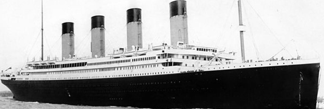
City of Rio de Janeiro, 1898 Photo: public domain
City of Rio de Janeiro, 1898
Photo: public domain

On 22 February 1901, the SS City of Rio de Janeiro, inbound from Hong Kong in thick morning fog, struck rocks near Fort Point-close to where the now famous Golden Gate Bridge is located-and sank taking with her 128 of the 210 passengers and crew aboard.  The sinking was so sudden (due to the catastrophic nature of the damage on the underside) that a nearby lifesaving station was unaware of it for 2 hours. Fortunately fisherman rescued survivors but the captain, William Ward, went down with the ship. Most of the passengers were Chinese and Japanese immigrants but one notable passenger was  Rounsevelle Wildman, who was the US Consul General at Hong Kong enroute with his family to Washington D.C. for the innaguration of President William McKinley. He and his family were lost in the sinking. Due to the depth, it was impossible at the time to dive to the wreck. Rumors of gold or silver have persisted despite the cargo manifest showing 2,423 slabs of tin aboard. Bodies of the dead would wash up on the nearby shore for a few years including that of Captain Ward.

Credit: Coda Octopus/NOAA

Most attempts to locate the wreck failed. One notable claim from 1931 was that it was located via submarine but the person making the claim later disappeared. In 1987 it was announced that it was found and a consortium named Seagamb Inc. would go down, look around, and see if the could find the rumored cargo of silver. While they initially got a permit it was revoked in 1990 because they did not live up to the terms specified. Another problem emerged more recently when another expedition sponsored the National Marine Sanctuaries Maritime Heritage Program (part of the National Oceanic Atmospheric Administration or known simply as NOAA)to document shipwrecks around San Francisco Bay found a discrepancy in the wreck’s location. The 1980 coordinates differed from U.S. government sonar scans of the area. At any at the problem has been cleared up. And with newer technology much clearer scans of the wreck along with three dimensional images allow us to see this wreck as never before.

Sources:
1. First Images Of ‘Titanic Of The Golden Gate’ Revealed(11 Dec 2014,CNN)
2. Revealing the Secrets of “San Francisco’s Titanic” (NOAA)


Summer in San Francisco

Most tourists learn quickly that while San Francisco can have nice and sometimes sunny days, that having a sweater or light jacket can come in handy. Especially in the early morning and often in the late afternoon when the fog comes in.

San Francisco Summer Photo: Brocken Inaglory(Wikimedia)
San Francisco Summer
Photo: Brocken Inaglory(Wikimedia)

There is a well known saying attributed to Mark Twain that says “The coldest winter I ever spent was a summer in San Francisco.” It sounds like something he might say and if you visit San Francisco one can be astounded how the weather can go from warm and mild to cold and breezy. Except Mark Twain never wrote it. He could have said it and someone wrote it down. People have searched through his writings, public and private, and cannot find he ever said it. He does seem to allude to it at one point when asked about a cold winter, which he replied “last summer” which may refer to San Francisco. How and where it originated is a mystery. Someone might have guessed he thought it and wrote it down and then got repeated.
Source: And Never the Twain Shall Tweet (Snopes.com)

Titanic News: Tinian Plans Titanic Themed Resort, Titanic Halloween Masquerade and Titanic Irish Whiskey Loses A Year

Map of the islands of Saipan and Tinian in the Northern Mariana Islands along the Marianas Trench (east of China and the Philippines). Image: Public Domain (US Geological Survey)
Map of the islands of Saipan and Tinian in the Northern Mariana Islands along the Marianas Trench (east of China and the Philippines).
Image: Public Domain (US Geological Survey)

1. Tinian, one of the principal islands in the Commonwealth of the Northern Mariana Islands, is planning a multimillion dollar Titanic-themed hotel and resort. The planned resort will be built on a 40,000-square-meter property on Tinian harbor. It will be built to look like it is sitting on water but built on land. Aside from the usual amenities resorts have, it will include a casino and banquet room. The decision to use a Titanic theme is due to the world-wide fascination created by Cameron’s Titanic. It is particularly popular in China, where the movie and soundtrack are very popular. And that is the goal of the resort, to attract tourists from Northern China. So many Chinese tourists will have a choice in a few years: go to a Titanic themed hotel and resort in Tinian or head into the interior and stand aboard a Titanic simulator.
Source:$130M Resort On Tinian OK’d(24 Mar 2014,Saipan Tribune)

2. If you are looking for Titanic themed Halloween masquerade party that will be on a ship, consider one in San Francisco for 2014. According to SFgate.com:
Prepare for the ultimate Halloween party cruise that will be transformed into a haunting Titanic, filled with over 300 Ghosts & Ghouls raised from the dead of the historic Titanic that sank hundreds of years ago.You will be picked up in the San Francisco Bay at Pier 40, where you’ll board the beautiful Fume Blanc Commodore Yacht. You’ll hit the city-lit bay on a 4 hour cruise, with some of the most vivid views of Treasure Island, Alcatraz, the Bay Bridge, Nob hill, the Golden Gate GateBridge, and the magnificent San Francisco Skyline. There are 3 amazing decks on the spacious 350 passenger Fume Blanc Commodore vessel. Seating will be ‘first come, first serve’ on the lower decks, but there will be some reserved seating on the 2nd level so that table service can have the best views of the all the gorgeous scenery.

Sounds fun but costumes/mask required to attend and tickets must be purchased in advance. Ghosts (real ones) admitted free. 🙂
Source: Titanic Masquerade Halloween(22 Mar 2014, SFgate.com)

3. Bad news for fans of Titanic Irish Whiskey. The five year old blend is being reduced down to four years reports The Spirits Business. Their current supplier will not supply a five year blend and with only 300 cases left to be divided on the international market, they made the business decision to drop to a four years or risk running out of whiskey. Okay so this is not strictly a Titanic news item but I happen to know many whiskey drinkers out there get upset when a whiskey maker lowers the aging. It costs approximately $47 for 700ml.
Source: Titanic Irish Whiskey Reduces Age Over Scarce Stocks(24 Mar 2014,The Spirits Business


Caltrain Musings

Caltrain
Photo: Wikipedia

*San Bruno Grade Separation Update
Good news! San Bruno & Huntington Ave street closure is over. It was closed on 20 September for massive construction that included lowering the grade under the San Bruno elevated railway section to accommodate more trucks. It was supposed to open on 30 Sept at 0500 but alas did not happen. So it was extended to Thursday at 8:00 p.m. And now the detour around that area is over. Huntington between Euclid and San Bruno Avenue has been nearly restored to its prior condition. When they began construction, the east side was closed except for construction traffic. That meant the west side, normally two lanes for southbound traffic, was converted into a two lane traffic zone for north and south traffic. It made driving difficult at times. Buses and other traffic that had to turn north from San Bruno onto Huntington had a difficult time. It was a tight turn to negotiate for buses. With one northbound lane now restored, it alleviates a traffic problem at the intersection.

Even better is that now the tracks are elevated, there is zero chance of a vehicle being stuck on the rails in that area. During construction there were two serious accidents. One involved a tractor trailer at Angus (to big and got stuck on the tracks) and the other at San Bruno Ave where someone abandoned a car on the track. A third minor one involved a car that got grazed by a train when it was just a little over that line (those lines are there for a purpose folks). Amazingly the car was driven away and found later by police at Bayhill shopping center.

For walkers though, the sidewalk in front of the old bank at Huntington & San Bruno is closed. You will need to detour to one of the crosswalks near Mills or Easton to cross over.

*Clipper Issue/Reminder About Tagging On & Off
Recently I had a small problem with Clipper. I tagged on in San Francisco and off at San Bruno station. But when I checked my account a few days later, I was charged to full amount rather than deducting a ride from my 8 Ride ticket. I emailed Clipper and they investigated the issue. They did refund the money but did deduct the fare (discounted for an 8-Ride ticket)from San Francisco to San Bruno since my 8 Ride Ticket by that time had expired. The problem was a rare one where the Clipper terminal was not properly sending the information. So always check your balance when paying with cash or by 8 Ride Ticket. Otherwise you might get a nasty surprise the next time you tag on.

Now about what happens if you forget to tag on or off. If you board the train in San Francisco or San Jose, chances are the conductors will check at the gate and turn you around to tag at the Clipper terminal. However if you do forget to tag on and the conductor aboard the train checks your card, simply put you are doomed. Conductors will issue a citation for fare evasion and you have to go to court. I think the fine is $380 (that includes court fees) but it could be more by now. Ignorance is no defense here since Caltrain has signs all over the place and conductors reminding everyone to tag on and off.

If you forget to tag off at your destination, Caltrain will assess the maximum one way ticket fare $12.75 and deduct it from the cash purse on your card. So remember to tag off when you get off the train. Otherwise if the cash balance on your card dips below $1.25, you cannot use it until you load cash. What happens if you do not have enough money on your card to pay the fare? What happens is you cannot use that card until you load cash and pay the negative balance on it. Remember except at San Francisco and San Jose stations, you cannot add cash to your Clipper card. Either go to Walgreens, a Clipper service center, call them up, or pay on the Internet.

*Important 8-Ride Ticket Reminders
-Cannot be used for zone upgrade. When you tag off, the cash needed for the extra zones traveled will be deducted.
-No all zones on weekends or holidays.
-Has a time limit of 30 days and then they go poof if not used.
-Can buy monthly parking permit.
-Must tag on at start of trip and at final destination. If you fail to tag off, you pay the maximum ticket of $12.75

Caltrain/Samtrans Alert
If a BART strike does occur, service to BART stations by SamTrans will be temporarily discontinued. This will effect Daly City, Colma, South San Francisco, San Bruno and Millbrae BART stations. So check with SamTrans or ask the bus driver for where the temporary stop is located if you using a bus that normally does go to a BART station. Caltrain has no plans to add extra trains as of yet, but expect some early morning commute trains to be even more packed when they depart Millbrae. Important tip: Express trains are almost always full (people standing in aisles), limiteds may be full (but not with people standing in aisles), and locals are generally have more seats available (they take longest to get to San Francisco). Plan accordingly. Bicyclists will likely have it even more tough when every seat and more is taken up.

Caltrain Sauna Effect
We have been having a some really warm weather. Sadly not all Caltrain cars have that air conditioning working right. One car I entered was warm enough for a sauna. Yikes! And the smell was pretty ripe as well.

Doors Do Not Lock Themselves
It is interesting to watch at San Francisco station (4th & King) as to who locks doors and who does not. Now usually the doors to tracks are locked when there is no need for them to be unlocked. And there is a security guard who does check. Sometimes the conductors will lock one side of the doors (the ones that will be open for the next departing train) and leave the opposite ones unlocked. And they clearly know this since I observe conductors go in and out of those doors as they get food or do other things. And train drivers are the worst. If a door is locked, they check the nearby ones. And then they walk to other ones nearby. Only if they cannot find one unlocked (or time is an issue), then they finally produce a key. But they rarely lock the door behind them (1-5 I observed locked and unlocked). They tell us to be observant about packages but if the conductors and drivers seem not to take much care in securing areas, it is no wonder why TSA wants to increase its presence in the railroad area. They might have to consider self locking doors that are always locked unless you insert a key and open it, and then lock when put back into place.